


Tom Quinn is in his 31st year as a geometry and calculus teacher at Northern Valley/Old Tappan High School. He was the Golden Knights’ girls soccer coach for 23 years, has been the boys golf coach for 12 seasons and is now back on the sidelines as the JV girls soccer coach. He took his first steps on the Appalachian Trail on January 1, 2019.
Quinn has logged a lot of miles since. He has walked the entire New Jersey, New York, Connecticut sections of the AT and is now about halfway through Massachusettes & Pennsylvanis. He shares some of his experiences, tips and tricks in our semi-regular Down The Trail feature.
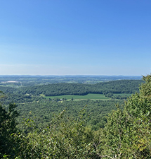
Pennsylvanis lookouts are pretty cool on the Appalachian Trail.
I am happy to announce that I am almost halfway through Pennsylvania at this point; closer to Harrisburg than Allentown, and closer to the Susquehanna River than the Delaware River. The Appalachian Trail meanders about 232 miles through Pennsylvania, and I suppose sometime, somehow I will complete the Keystone State.
The most recent section I completed, along with my brother Rob, was a neat one. A varied hike with open viewpoints to the Pennsylvania valleys below, quarter mile long rock fields that northbound hikers will come to know, and some casual walks through easy ups and downs. This near 12 mile, 5-and-a-half hour hike would be one I might do again …. if I lived a closer to the location, that is.
The hike started along Route 645 at an AT parking location. I have no idea what town I was near at this point. The first 2 miles would have been an awesome hike in the fall, as there were several open viewpoints to the valley below. The Fisher Lookout and Kimmel Lookout were the main views in the early going, and the terrain was not too difficult. This allowed me to watch the views and not worry so much about watching my feet.
After crossing Route 501, the trail leveled off to a gentle walk in the woods. There is a shelter aptly named The 501 Shelter here, which is a nice, two-story structure that I am sure many thru hikers use. The shelter is taken care of by a guy who lives right next to it. Compared to many of the shelters I passed on the trail, this one was one of the better ones. The shelter is close to Rt 501, and I was told food is often delivered here with ease. Can this hike get any easier! LOL
The trail continued over a couple of decent length rock fields; northbound hikers might be fooled thinking that the nickname “Rocksylvania”, given to Pennsylvania, isn’t really that bad after all. These same northbound hikers have no idea what they are up against in their near future. I have hiked Pennsylvania northbound, but backwards (if that makes sense), and as I have said before, parts of the AT in PA closer to NJ are filled with bus-sized rocks that hikers have to traverse. I wish them luck, but remember … I did it!
As the hike progressed, it started to get a little easier. There was a nice descent to a campsite, and gradual ascent afterwards that was a heart-pumper that got my attention. There was also a nice, half-mile “fern field” that we hiked through which reminded me of what one would see while hiking through Harriman State Park (NY). We also passed a 1,200 milemarker (in rocks) on the trail. Northbound thru-hikers would be excited to pass this number, as they could say “1,200 down, 1,000 to go” to get to the end of the AT in Maine. We kept a good, 2 mph pace and really had a good walk today. Truthfully, I think Rob likes these hikes more than I do; he could easily increase the pace to a 2.5 mph clip if it was his choice.
The AT had a little detour towards the end, which made the hike a little longer than I thought it would be, but we eventually ended up on Rt 183, near Bernville, PA. We didn’t see a road for almost 10 miles, and upon exiting the woods we immediately saw trucks barreling down the highway!
Hikers be careful, but keep trucking!
TO BUY A COLLECTOR'S PRINT OF THIS STORY PLEASE VISIT 4-FeetGrafix.com.